
Understanding Topographical Land Surveys
Topographical land surveys are crucial for any construction or development project. They meticulously map out both natural features like hills and rivers, and human-made structures, providing an accurate representation of the terrain. By understanding the contour and elevation of a site, architects, engineers, and developers can make informed decisions that guide the planning and design process. For those in London and surrounding areas, seeking expert services in topographical land surveys london ensures that you receive the detailed data needed for successful project execution.
What is a Topographical Land Survey?
A topographical survey, often referred to as a land survey or topo survey, is a detailed, scale-based mapping of a specific parcel of land. This process captures the configuration of the terrain, including both natural and man-made features, such as:
- Elevation changes and contour lines
- Vegetation and natural resources
- Structures including buildings, roads, and fences
- Boundaries and other property lines
The output of a topographical survey is a comprehensive map that enables architects, engineers, and planners to visualise the land’s attributes and how they will interact with any proposed developments.
Key Features of Topographical Surveys
Topographical land surveys are distinguished by their focus on both horizontal and vertical measurements, providing crucial data for the design and construction of various projects. Key features typically captured in these surveys include:
- Detailed contour mapping that highlights elevation
- Identification of significant features like trees, buildings, and water bodies
- Utilities and existing infrastructures, such as drainage systems
- Land boundary indications and easements
This rich data set is essential for achieving accurate planning and effective project management.
Benefits of Topographical Surveys for Planning
Employing a topographical survey offers numerous benefits that are especially pertinent for planning purposes:
- Accurate Planning and Design: The insights from a topographical survey enable precise aligning of structures with the terrain.
- Identify Constraints and Hazards: They highlight potential flood zones and unstable ground that may pose risks during construction.
- Support for Planning Applications: Many local authorities require a topographical survey as part of the planning application process.
- Prevent Costly Errors: Reliable data helps avoid structural problems and reworks associated with inaccurate land data.
- Property Boundary Clarity: It aids in establishing clear ownership lines, which is crucial for legal documentation.
Why You Need a Topographical Survey
Topographical surveys are not merely beneficial; they are essential for various development projects. Failing to conduct one can lead to complications that may severely delay a project or inflate costs significantly. Below, we discuss the primary reasons for obtaining a topographical survey.
Common Applications in Development Projects
Topographical surveys find applications across numerous sectors, including:
- Construction: Essential for determining site specifications and ensuring compliance with design requirements.
- Urban Planning: Aiding planners in understanding land use and potential development impacts.
- Environmental Assessments: Providing data for ecological studies and environmental impact assessments.
Thus, whether for small residential projects or large commercial developments, topographical surveys furnish the necessary data for informed decisions.
Legal Considerations for Planning Applications
When submitting planning applications, local councils often mandate the inclusion of a topographical survey to ensure compliance with zoning laws and regulations. These documents help demonstrate that proposed developments align with existing land use and environmental conditions, ultimately expediting the planning process.
Risk Management and Site Safety Enhancements
Topographical surveys enhance the safety and risk management aspects of construction projects. By identifying potential hazards such as flood zones or unstable ground, they allow engineers and site managers to devise strategies to mitigate these risks, ensuring a safer working environment.
Who Needs Topographical Land Surveys?
Topographical surveys serve a wide range of professionals across various industries. Understanding who needs these services helps clarify their importance in project planning and execution.
Architects and Engineers’ Dependency on Survey Data
Architects and engineers rely heavily on accurate survey data to inform their designs. By understanding the topography of a site, they can create structures that not only fit the land but also withstand environmental challenges.
Land Developers and Construction Companies
For land developers, detailed topographical surveys provide essential information for site development, including the layout of roads and drainage systems. Construction companies depend on these surveys to ensure projects progress smoothly and within regulatory parameters.
Real Estate Professionals and Homeowners
Real estate professionals leverage topographical surveys for accurate property assessments. Homeowners might seek these services when considering landscaping or extension projects, as it provides critical information for optimal designs.
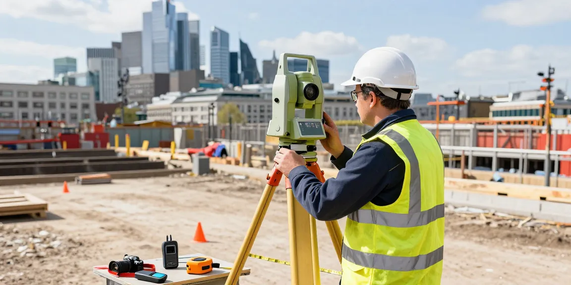
Modern Equipment Used in UK Topographical Surveys
The advancement in surveying technology has transformed how topographical surveys are conducted. Today’s surveyors employ various modern equipment to ensure precision and efficiency.
The Role of GPS and GNSS Technology
Global Navigation Satellite Systems (GNSS) technology has revolutionised surveying by providing quick and accurate positioning data. This is particularly advantageous for large or complex sites, where traditional surveying methods may be time-consuming.
3D Laser Scanning: Benefits and Applications
3D laser scanning, or LiDAR technology, captures millions of data points in a fraction of the time it takes with traditional methods. This technology is ideal for creating detailed 3D models of both natural and built environments, enhancing visualisation and planning.
Utilising Drones for Comprehensive Mapping
Unmanned Aerial Vehicles (drones) are becoming increasingly popular for gathering topographical data, especially in hard-to-reach areas. Equipped with high-resolution cameras and photogrammetry software, drones provide a bird’s-eye view that enhances mapping accuracy and detail.
Cost and Coverage of Topographical Surveys in the UK
The cost of a topographical survey can vary significantly based on several factors, including site size, complexity, and location. Understanding these factors can help stakeholders budget accordingly.
Pricing Models for Different Project Sizes
On average, the cost of topographical surveys ranges from £450 for small residential plots to £1,500 or more for larger commercial sites. Fixed pricing models are typically offered, ensuring no hidden fees complicate budgeting.
Geographical Areas Covered by Surveying Services
Topographical survey services often cover extensive geographical areas, including major urban centres like London and Surrey. Service providers usually have local knowledge that enhances their ability to navigate planning regulations effectively.
Getting a Fixed Quote: What to Expect
When seeking a topographical survey, it’s advisable to obtain a fixed quote. Providers typically request details about the site, including its size and specific requirements, to generate tailored pricing. This can help avoid unexpected costs down the line.
What are typical timelines for topographical surveys?
Timelines for topographical surveys can vary based on project size and complexity, but most surveys can be scheduled and completed within a few days to weeks. Advanced technology aids in expediting the data collection process, ensuring timely delivery of survey results.
Are topographical surveys essential for all construction projects?
While topographical surveys are crucial for most construction projects, their necessity can depend on the project’s scale and complexity. Smaller projects may not always require them, but engaging a surveyor for even minor developments is often advisable to mitigate risks.
What technologies enhance the accuracy of land surveys?
Technologies such as GNSS, 3D laser scanning, and drone surveying enhance the accuracy of land surveys. These tools provide precise measurements that help reduce errors and improve the overall quality of the surveys.
How do topographical surveys assist in boundary disputes?
Topographical surveys can clarify property lines and boundary changes, providing essential documentation that can resolve disputes between neighbours or parties involved in land transactions.
What factors can affect the cost of a topographical survey?
Factors affecting the cost of topographical surveys include site size, location, accessibility, and the complexity of the terrain. Additionally, the level of detail required in the survey will also play a significant role in pricing.